


 |
 |
 |
 |
 |
 |
 |
 |
 |
 |
 |
 |
 |
 |
 |
 |
 |
 |
 |
 |
 |
 |
 |
 |
 |
 |
 |
 |
 |
 |
 |
 |
 |
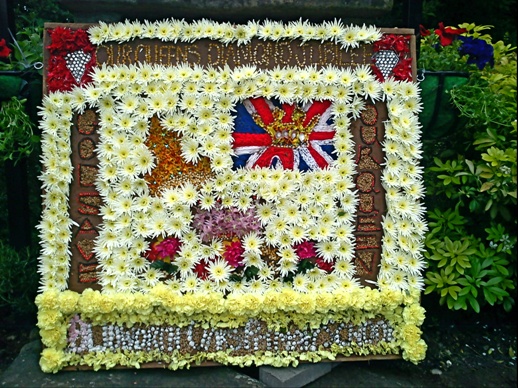 |
Well Dressing by Blidworth Oaks Primary School to celebrate Queen Elizibeth II diamond jubilee on 5th June 2012

The Domesday Book includes the village of Blidworth in its
chronicles. We can therefore assume that there was a supply of pure water for
the inhabitants to drink. In fact Blidworth is most fortunate as sitting upon
an almost endless supply of underground water that is trapped in the Bunter
Sandstone that covers much of Nottinghamshire. The water table under Blidworth
generally follows the lie of the land and so rather than there being a
horizontal layer of water saturated sandstone the water table roughly follows
the contours of the area.
This would explain why some of the wells of Blidworth had to
be excavated to almost one hundred and fifty feet and why at any time of high
rainfall, springs run freely from the highest point of the village. This is
still evident as you travel the road beyond the Church of St Mary’s down the
road towards Fishpool. The north side of the road near Clay Bank Villas is
often running with spring water from the land nearby.
Any description of the wells and water supply of Blidworth
has to include information and material previously researched by Blidworth
local historians Shelia Stokes and Will Richards and grateful acknowledgement
is given here for their immensely important contributions.
Thomas Langdon’s map of 1613 shows ‘Parte of Blithe worth’
and there are two ‘High welles’ marked to the southwest of the village. The
first chronicled ‘water well’ excavation was that by J.P. Briscoe in the Parish
Register of 1894 and it concerned the tragic event of an Eakring* mason, John
Allen, who was killed when a bucket of spoil broke from the hauling rope and
landed on him. This was on the 31st March 1629 and he was buried the
same day in St Mary’s Church. There is a pavior in the church inscribed with
emblems of tools of a freemason’s trade, a hammer and square and this could be
where John Allen is buried but it is more likely that it marks the grave of the
mason who was killed in 1736 whilst digging a vault. The well could have
belonged to Thomas and Mary Crammer who are recorded as living at Rockside in
1676. On October 7th 1985’ workmen were clearing the site at
Rockside, close to the summit on Field Lane, where one of the oldest houses in
the village had stood and discovered a well that was 114feet deep.
Having access to pure water was vital to every inhabitant of
the village and disputes over the right to draw water were inevitable. One
argument had to judged in the Nottingham Midsummer Assizes. It was reported in
the Nottinghamshire Guardian of 29th July 1864 that a Mr Boothroyd,
the landlord of cottages near Blidworth was claiming £25 from a Mr Slaney for
trespass on and damage done to a well belonging to him. ‘Betty Kirton’s well’
had been dug in 1819 by a Mr Singleton on waste land near the road but was then
enclosed and tenants of the cottages had to pay for the privilege of drawing
water.
It appears from the report that
witnesses were divided on whether the amount to be paid was 2s 6d or 5shillings
(25p) and whether the money was for the water or for the maintenance of the
well. Everyone, other than Mr Boothroyd believed they had the right to draw
water whether it was paid for or not. Mr Boothroyd stopped the use of the well
by having it nailed up but Mr Slaney broke off the planks of wood. This
happened twice and the case was taken to court. It must have been quite an
expensive case as solicitors acting for both Boothroyed and Slaney instructed
lawyers to argue their points of view to the jury. Mr Boothroyed won his case
but rather than the £25 he was claiming he was awarded only one shilling (5p).
It is not known what happened to the well after the court case but it seems
that the judge had some sympathy for the tenants by awarding only a small sum
in damages.
One
well that can be seen (see photo above) is at the top of Surgery Lane. This area, which once had
the overnight ‘lockup’ and pinfold, is now a focal point of the village as it
has the Remembrance Memorial and flower garden beautifully maintained by Aubrey
Musson. In 1982 the children of the Methodist Church Sunday School dressed the
well in flowers. They were inspired by the well dressings of Derbyshire. The
photograph shows the children gathered for the Blessing of the well.
This well was very deep and the story goes that when workmen
were filling it by tipping in rubble they were getting tired and decided to see
how much further they had to go. 115ft (35m) of line was paid out before the
top of the infill was reached. In conversation with Will Richards he said it
was Tony Ulyett who was filling it and who measured its depth.
Sam Clarke, who fetched water from this well wrote, ‘Beautiful
sparkling water! – but very hard. Whenever a new bucket or rope was needed the
cost was ascertained and the amount was collected by my father and John Ashley (another
shoemaker who lived across the street) from those who used the well. It was
quite a feature of our end of the village for men to foregather and draw their
daily water-supply, and while waiting their turn to discuss the latest news –
local or news from further afield. No water was drawn on Sunday: water for use
on Sunday was drawn on Saturday evening’.
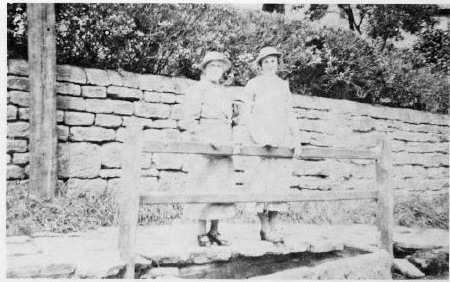
Surgery Lane well
circa 1920's
All well water was hard** and many people had large tubs to
catch rainwater from the roofs of their houses or outbuildings. In a dry summer
the tubs would empty and people would walk to ‘Softwater Trough’ for supplies.
This spring rarely, if ever dried up, until relatively recently. Will Richards
mother was born at Norwood Farm in 1872 and he relates that when a girl, in a
dry summer, her job was to collect water from ‘Softwater Trough’.
Over the years all of the wells were filled in but many, at
first, were just covered over with timber. There was one on the boundary
between 15 and 17 Main Street and in the 1980’s Albert Meakin was walking
between his daughter’s house, No.15 and his own, No.17, by way of the garden
path when suddenly he disappeared. He had discovered an old well! The wood that
had covered the well and was overgrown itself, had rotted away and down he
went. Fortunately the well had been partly filled in but he was far enough down
for him not to be able to climb out again. He called to Flora, his wife but she
being a little deaf didn’t hear him until she became worried as to where he had
got to and went to look for him. When she did find him she wanted to know what
he was ‘doing down there!’
His reply is not recorded!
She had to get a
neighbour, Jeff Kirman, who let a ladder down to him so that he could climb
out. The family still laugh about it.
Once there was a piped water supply to the village, less use
was made of the wells although they were needed when the local pumping engine
failed. After the Blidworth Colliery was sunk in the 1920’s the water table
would have lowered and this led to many wells drying up. People would then start
to fill in their wells but it is known that one man at Mount Pleasant used to
slaughter his pigs over the well at No.32 in order to drain away the
blood!
*Clowne, according to Will Richards.
**Water that has high concentrations of minerals such as
calcium and magnesium and is difficult to get to lather and therefore wash in.
There are many recorded wells in Blidworth and these are
marked on the maps shown. (To be added).

1. At
Rock Farm. Thought to date from 1780.
2. At
Clay Bank. Sheila Stokes says it was under a pond in front of a gate leading
into a field. The O.S. map shows one at the southern edge of the road.
3. On
Mount Haven Cottage garden, Ricket Lane. There might have been another near an
outside toilet. At the time of a Mr Godfrey the ‘Well Head’ was moved to
Nottingham Castle. It has since been returned to the village and now sits above
the well at the top of Surgery Lane, albeit, we are told by Will Richards, at
the wrong angle by 90 degrees!
4. At
Woodstock, Ricket Lane.
5. At
Red Gate Farm in a field off Ricket Lane.
6. St
Mary’s Church, probably near the roadside.
7. There
were two at Hill Top Farm. One was in the house in the sitting room and one was
against steps.
8. ‘Top
House’ had three but it is not known exactly where.
9. There
was one against the Windmill off Ricket Lane.
10. There were three
on Ashwell Terrace. In front of No. 3 and ‘The Croft’ and at the back of No. 5.
However Shelia Stokes writes that on 12th October 1991, Ron Brookes
opened up a stone built well at No. 2 and found water at five feet down. The
well itself being about sixteen feet deep.
11. There were two at
Cliff Farm, one in the kitchen and one outside the front door.
12. The well in the
School House was covered with one large slab of stone for many years. In 1876
the water was 15 feet from the surface.
13. In Wheeldon’s
Yard, near the bottom, there was a well against ‘Miss D Clay’s’ gate – this
would be circa 1990.
14. At The Orchards,
in the garden.
15. At Blidworth Farm
an outside well which in 1990 had a pump over the top of it.
16. At Beech Holme
there were two, one under a passage floor and one outside under the porch.
17. At Holme Cottage
there might have been one under the pantry floor although this has also been
described as a ‘brick tank’.
18. At The Laurels
there were two, one inside and one out.
19. At Forge House
outside.
20. Inside ‘Miss
Heath’s’ house. Probably in the front room! This house was adjacent to the
White Lion which itself was next to the Red Lion.
21. In front of a
house in White Lion Yard.
22. At Grove Farm the
well was said to be ‘very, very deep’ - Shelia Stokes.
23. At Surgery Lane.
This can still be identified by the ‘well top’, originally from Mount Haven, on
Ricket Lane.
24. On Beck Lane
there was a well, to the left, in what Shelia Stokes describes as ‘Doug Asbury’s
garden, near the coal garage’.
25. In Flears Yard.
‘Against Mr Moore’s house’, – Shelia Stokes
26. There were two on
the boundary between houses 13/15 and 17 Main Street. There was some evidence
of another in the garden of no.15.
27. Behind No’s 1 to
11 Main Street, known as ‘Sugar Row’ during and after the second World War as
the American service men living there always had plenty of sweets to give away.
One was six feet (nearly two metres) across and the position was shown to us by
Taff and Jane Jenkins who live at No. 9.
28. Behind No 32
Mount Pleasant.
29. On New Lane.
30. On Mansfield
Road. Perhaps called ‘Little Farm’.
At Norwood Hill Farm.
This was the birthplace of
Will Richards mother. There was also a large tank under the main room that
collected rain water from the roof.

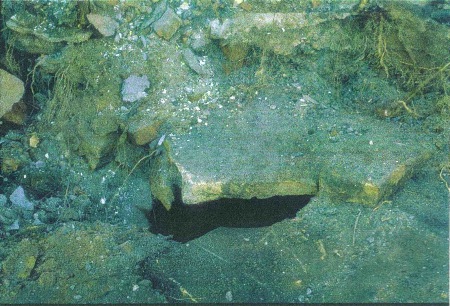
60ft well discovered when excavating to build at the top of Field Lane (now filled in)
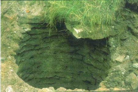
The well shaft

Besides wells, water for household use was gained from
natural springs that rose near to the highest point of the village and flowed
downhill. Will Richards writes:’ The water from the springs was piped into
troughs and cisterns on its way through the village. I remember when the water
from Ashwell Croft ran into a trough in a cave-like excavation under where No.1
Kirk’s Croft has now been built. From there it ran into a trough at the
roadside………At one time spring water was piped to Beecholme, and there was a
well at the point where the front porch has since been built. There was a
cistern in the house now called Mabel’s Cottage. Spring water ran to the ‘Black
Bull’ and into a trough called Bull Trough in the middle of the village square.
Then through the ‘Red Lion’ into the cellar of the house on the corner next to
the ‘White Lion’……….From there it ran to a trough close to the pinfold near the
bottom of Beck Lane where stray animals were impounded.’
Will Richards tells us that when a boy and the pumped water
supply failed, his job was to go across the road to Miss Heath’s house (the
house on the corner next to the ‘White Lion’) and fetch spring water from the
cellar under the back kitchen. This house was demolished in about 1972.
Water would continue down Main Street at the side of the
road and eventually find its way down Dale Lane, possibly as far as the site of
‘The Jolly Friar’ public house. Mrs Minnie Cowdell, daughter of Pratt Brown,
was born at 17 and then lived at 19 Main Street said that there was an
intermittent stream that came down from Rook Wood and flowed between 15 and 17
and then into Main Street.
The stone trough at the bottom of the picture stood on Main Street between the Church and Black Bull square and was fed by a spring.
Will Richards remembers the Dover Beck that rose near
Rickett Lane and flowed down towards the ‘Little John’ public house. At
Fishpool, centuries ago, it formed ponds that held fish and gave the area its
name. It then crossed the road and ran towards Blidworth Bottoms, flowing
behind the ‘Fox and Hounds’ public house. Its course took it through an area
known as Long Wood then across the old Rufford Road (now the A614) and on to
Salterford Dam. Will remembers the exceptionally cold winter of 1933 when the
water in the Dam froze over and he went skating on the ice.
By 1884 the wells and springs of Blidworth were
deemed to be inadequate for the needs of the village and from June until that
October the water troughs had been dry. A report was presented to the Mansfield
Rural Sanitary Authority that proposed installing a piped water supply and this
was agreed to. Drilling a borehole near the summit of the village was thought
too expensive and at first a site on allotments close to where the present
Tesco is, was considered. However this area was where much of the village
sewage flowed to and water from here could become contaminated. The site that
was chosen was to the west of the village near Fishpool. A six foot (almost two
metre) diameter well was suggested and the Report went on to recommend ‘ a
small steam engine with a vertical boiler (be) put down to work a set of
three-row lift and force pumps, capable of lifting about 50,000 gallons per day
of 24 hours’. As 20,000 gallons a day was thought to be sufficient for the 1000
inhabitants the pump would only need to work for three days a week. Water would
be pumped up to the top of the village through 4inch (10centimetre) pipes and
discharged into a round, brick built reservoir. This would hold one and a half
days supply and from here 3in and 2 1/2in pipes would take water to all parts
of the village as far as Mount Pleasant. The estimated cost of the work was as
follows:-
Engine house, sinking well and fixing machinery £400
For mains,
hydrants, distribution-pipes and sluices £650
For reservoir
and fittings £200
Total,
exclusive of land, legal and professional charges £1250
The reservoir was built between the windmill and Ricket Lane
and by the middle 1880’s most village houses had a water tap. The pumps chosen
were simple oil driven engines and Will Richards has written that Ern (in
conversation he called him Len) Revill, from Fishpool, was employed to start
the pumping and after so long would drive his motor bike (if he could get it
started) up to the reservoir to check on progress. Often, he would get there to
find the water overflowing, causing a six foot waterfall where Rickett Lane
joined the main road! A pressurised supply was installed in the 1920’s, Severn
Trent Water now has the original pumping house site and the reservoir has been imaginatively converted into a house.
The ‘new village’ had its water supply provided by a
borehole in the colliery. The reservoir being opposite to where the Miner’s
Welfare Hall stood until the colliery closed in 1984.
Research is ongoing and photographs and details will be
updated as they become available.
We would like to thank Shelia Stokes and Will Richards for
their invaluable help but wish to include thanks to Bill Hutton, Eric Hall,
Philip Jones, Tom Murray and Patrick Turk for their support.
Additional information and/or photographs are always
welcome.
John & Dale Smallwood November 2010